Historical cities represent living museums where centuries of human civilisation converge in tangible, walkable spaces. These urban centres offer visitors the extraordinary opportunity to witness the evolution of architectural styles, urban planning philosophies, and cultural traditions through direct experience. Unlike static museum displays, historical cities pulse with contemporary life whilst preserving their ancient character, creating a unique temporal dialogue between past and present.
The fascination with historical cities stems from their ability to provide authentic encounters with our collective heritage. Every cobblestone street, weathered façade, and preserved monument tells a story of human ambition, struggle, and creativity. These urban landscapes serve as repositories of knowledge, where archaeological discoveries continue to reveal new insights about how our ancestors lived, worked, and organised their societies.
Modern travellers seek more than superficial tourism experiences; they crave meaningful connections to place and culture. Historical cities satisfy this desire by offering multi-layered narratives that engage all the senses and stimulate intellectual curiosity.
Architectural heritage and urban morphology in historical city centres
The architectural landscape of historical cities functions as a three-dimensional timeline, revealing the progression of building techniques, aesthetic preferences, and social structures across different periods. Each era has left its distinctive mark on the urban fabric, creating complex palimpsests where Gothic spires rise beside Renaissance palazzos and Baroque churches neighbour Art Nouveau townhouses.
Urban morphology—the study of city form and structure—provides crucial insights into how historical cities developed organically over time. Unlike modern planned cities with their geometric precision, historical centres evolved through centuries of incremental growth, adaptation, and reconstruction. This organic development process has created the irregular street patterns, varied building heights, and intimate public spaces that give historical cities their distinctive character and human scale.
Medieval street patterns and gothic cathedral complexes in canterbury and york
Medieval city centres like Canterbury and York exemplify the organic urban development that characterised European cities during the Middle Ages. These cities feature narrow, winding streets that follow ancient pathways and property boundaries established centuries ago. The street networks reflect the practical needs of medieval society: defensive considerations, trade routes, and religious processions all influenced the layout of thoroughfares.
Gothic cathedral complexes dominate these medieval cityscapes, serving as both spiritual and architectural focal points. Canterbury Cathedral, with its soaring perpendicular Gothic towers, demonstrates how medieval builders pushed the boundaries of engineering to create structures that literally reached towards heaven. The cathedral precinct includes cloisters, chapter houses, and subsidiary buildings that reveal the complex institutional life of medieval religious communities.
Renaissance urban planning principles in florence’s oltrarno district
Florence’s Oltrarno district showcases Renaissance urban planning principles that emphasised symmetry, proportion, and classical architectural orders. The Pitti Palace and its extensive Boboli Gardens demonstrate how Renaissance planners integrated architecture with landscape design, creating unified compositions that reflected humanist philosophical ideals about harmony and mathematical perfection.
Renaissance architects like Brunelleschi and Alberti developed new approaches to urban space that balanced individual building design with broader urban compositions. The result is a cityscape where individual palazzos contribute to larger architectural ensembles, creating visual coherence whilst allowing for architectural innovation and artistic expression.
Baroque façade systems and spatial organisation in prague’s lesser town
Prague’s Lesser Town (Malá Strana) presents exceptional examples of Baroque architectural principles applied to urban design. The district’s palaces feature elaborate façade systems with dramatic sculptural decoration, curved forms, and dynamic interplay between light and shadow. These buildings were designed to create theatrical urban experiences that engaged viewers emotionally and spiritually.
Baroque spatial organisation emphasises axial relationships and dramatic vistas that guide movement through urban space. The approaches to Prague Castle exemplify this principle, with carefully orchestrated sequences of spaces that build anticipation and culminate in spectacular architectural revelations. This orchestrated experience transforms simple navigation into a form of urban theatre.
Industrial revolution infrastructure integration in edinburgh’s new town
Edinburgh’s New Town represents one of the finest examples of planned urban development during the Industrial Revolution period. Designed in the late 18th century by James Craig, the New Town demonstrates how Enlightenment principles of rationality an
rational order were translated into broad avenues, regular squares, and harmonious terraces. The integration of early modern infrastructure—wider carriageways, improved drainage systems, and later, gas lighting—demonstrates how a historical city can adapt to technological change without sacrificing aesthetic coherence. The New Town’s grid pattern, punctuated by generous public gardens, also illustrates how the Industrial Revolution’s economic growth was balanced by a new concern for liveability, ventilation, and public health in dense urban environments.
Walking through Edinburgh’s New Town today, you experience a cityscape that still reflects 18th- and 19th-century social hierarchies. Grand townhouses along George Street or Charlotte Square speak to the aspirations of the professional and merchant classes, while smaller lanes and mews reveal the service infrastructure that supported elite lifestyles. For visitors interested in how the Industrial Revolution reshaped everyday life, Edinburgh offers a tangible example of how infrastructure, social order, and architectural style became intertwined within a historical urban fabric.
Art nouveau movement architectural elements in brussels’ ixelles quarter
Brussels’ Ixelles quarter is one of Europe’s most compelling districts for exploring Art Nouveau architecture within a living city. At the turn of the 20th century, architects such as Victor Horta and Paul Hankar experimented with new construction materials and fluid decorative forms, leaving behind a remarkable concentration of townhouses and apartment buildings. Characteristic Art Nouveau elements—sinuous ironwork, organic floral motifs, stained-glass windows, and asymmetrical façades—turn ordinary residential streets into open-air design galleries.
What makes Ixelles particularly fascinating is the way these Art Nouveau façades interact with older and more modern structures. Rather than existing in isolation, they form part of a layered streetscape in which 19th-century neoclassical houses, early 20th-century modernist blocks, and contemporary infill all coexist. This juxtaposition helps us see historical cities as evolving organisms rather than frozen relics. As you stroll through Ixelles, you can observe how changing tastes, materials, and regulations left their mark on the same urban lots over successive generations.
Archaeological stratification and cultural layer analysis
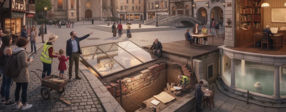
Beneath the surface of many historical cities lies a complex archive of human activity preserved in layers of soil, rubble, and reused foundations. Archaeological stratification allows us to read this vertical history, much like leafing through the pages of a well-worn book. Each layer reflects different building phases, destruction events, or shifts in economic and social life, offering clues that written records alone may not reveal.
For travellers, understanding these hidden archaeological layers adds a powerful dimension to exploring historical cities. When you stand in a bustling square or modern financial district, it is intriguing to realise that metres below your feet may lie Roman roads, medieval workshops, or even prehistoric settlements. Archaeological excavations and open-air displays in city centres help transform abstract timelines into concrete, walkable experiences that connect you directly with the deep past.
Roman foundation excavations beneath london’s financial district
London’s financial district, the City of London, sits atop the remains of the Roman settlement of Londinium founded in the 1st century CE. Over the past decades, large-scale construction projects have revealed extensive Roman foundations, roads, and public buildings. Careful archaeological stratification studies have documented everything from timber quays along the Thames to masonry warehouses, temples, and domestic quarters that pre-date the modern skyscrapers by nearly two millennia.
One of the most evocative sites is the London Mithraeum, where visitors descend below street level to view the remains of a Roman temple dedicated to the god Mithras. Here, lighting, sound, and digital projections recreate aspects of the sanctuary’s atmosphere, helping you imagine the rituals that once took place on this same spot. Elsewhere in the City, museum exhibits display artefacts unearthed during office-tower developments, illustrating how rescue archaeology and commercial construction can cooperate to preserve and interpret a historical city’s earliest layers.
Byzantine settlement patterns in istanbul’s sultanahmet peninsula
Istanbul’s Sultanahmet Peninsula offers an exceptional case study in how archaeological stratification reveals overlapping urban identities. Once the heart of Byzantine Constantinople, this area contains remains of imperial palaces, forums, churches, and defensive walls that predate many of the Ottoman monuments that now define the skyline. Excavations near the Hippodrome, the former centre of public life, have uncovered residential quarters, workshops, and water systems that chart the city’s development from late antiquity through the medieval era.
By analysing building foundations, street alignments, and reused blocks of stone, archaeologists have reconstructed Byzantine settlement patterns that often diverge from modern street grids. Visitors walking from Hagia Sophia to the Blue Mosque are unknowingly tracing routes that follow, distort, or entirely overwrite earlier thoroughfares. This layered spatial history illustrates how successive empires adapt inherited urban frameworks to new religious, political, and commercial needs, turning the historical city into a palimpsest that rewards careful observation.
Medieval occupation deposits in rothenburg ob der tauber
Rothenburg ob der Tauber, with its famously preserved medieval walls and timber-framed houses, appears at first glance like a city frozen in the 15th century. Yet archaeological work beneath courtyards, cellars, and public squares has revealed deep occupation deposits extending back to earlier medieval and even pre-medieval phases. These layers contain domestic refuse, building debris, ceramics, and tools that illuminate how daily life evolved across centuries of urban growth and contraction.
For example, changes in pottery styles and imported goods found in the stratigraphy demonstrate shifting trade networks and consumer habits, while evidence of fires and rebuilding episodes help explain irregularities in the current street plan. As you wander Rothenburg’s lanes, knowing that multiple generations built, demolished, and rebuilt on the same plots can transform a picturesque façade into a starting point for imagining vanished houses and forgotten livelihoods. This awareness turns a historical city visit into a form of time travel grounded in physical evidence.
Multi-period site interpretation at bath’s roman baths complex
The Roman Baths complex in Bath provides a particularly clear example of how archaeological stratification can be presented to the public in an engaging way. The site combines Roman bathing facilities, later medieval structures, and 18th-century Georgian developments into a single interpretive circuit. Carefully designed walkways allow you to move between levels, looking down onto Roman pavements while seeing, above and around you, the later architecture that redefined the spa town.
Interpretive panels, reconstructions, and audio-visual displays explain how the sacred hot springs remained a continuous focus of human activity from the Roman period through the Middle Ages and into the modern era. Rather than privileging one “golden age,” the presentation highlights continuity and change across multiple periods. This multi-layered approach encourages visitors to think about historical cities as dynamic cultural landscapes, where each era reinterprets and builds upon what came before.
Historical narrative documentation and primary source materials
While stones and stratigraphy reveal much about a historical city, written and visual sources provide an essential narrative framework. Chronicles, administrative records, maps, travel accounts, and personal letters all contribute to a richer understanding of how inhabitants perceived and organised their urban worlds. When you walk through a historical quarter knowing that a particular street is mentioned in a 14th-century chronicle or a 19th-century diary, the cityscape becomes infused with voices from the past.
Primary sources also help you compare official representations of the city with lived experiences. Did municipal records emphasise order and prosperity while private letters complained of overcrowding and noise? Did foreign visitors marvel at monuments that local residents took for granted? Engaging with these different narratives turns a simple city tour into an exercise in critical historical thinking, allowing you to see that every historical city has multiple, sometimes competing, stories.
Medieval chronicle analysis in carcassonne’s fortified cité
The fortified Cité of Carcassonne in southern France owes much of its fame to its dramatic double walls and castle, but medieval chronicles provide crucial context for understanding why this fortress-city mattered. Latin and vernacular sources describe Carcassonne’s role in regional power struggles, crusading campaigns, and religious conflicts. By comparing these narratives with the surviving fortifications, historians can assess how accurately chroniclers represented the city’s defences and urban life.
For visitors, references in medieval texts to specific gates, towers, and market areas create a more personal connection to the built environment. When you pass through the Narbonnaise Gate, you can recall accounts of armies mustering outside the walls or merchants entering for major fairs. Many guided tours now incorporate translated excerpts from chronicles, allowing you to hear the words of contemporaries as you explore the streets they once knew, turning the Cité into both an architectural and literary experience.
Ottoman administrative records in sarajevo’s baščaršija quarter
Sarajevo’s Baščaršija quarter, the historic bazaar and commercial heart of the city, is documented extensively in Ottoman administrative records. Tax registers, waqf (endowment) deeds, and court documents list shops, workshops, inns, and religious foundations in meticulous detail. These sources enable historians to reconstruct the economic geography of Baščaršija, identifying where particular crafts clustered and how trade routes connected Sarajevo to wider regional networks.
Walking through the quarter today, you can still see traces of this Ottoman-era organisation in the grouping of metalworkers, leather artisans, and coppersmiths along particular streets. Knowing that these patterns are supported by 16th- and 17th-century records deepens your appreciation of the area as a long-standing commercial ecosystem rather than a simple tourist marketplace. It also underscores how historical cities preserve intangible heritage—such as craft traditions and social practices—alongside tangible monuments.
Colonial period trade documentation in boston’s beacon hill
Boston’s Beacon Hill, now known for its brick townhouses and gas-lit streets, was closely tied to maritime commerce during the colonial and early federal periods. Shipping registers, customs records, and merchants’ account books reveal how goods flowed through Boston’s port and into the warehouses and shops that once occupied the lower slopes of Beacon Hill. These documents detail cargoes of molasses, rum, textiles, and household goods, painting a vivid picture of a city deeply connected to Atlantic trade networks.
As you explore Beacon Hill today, interpretive plaques and museum exhibits draw on these primary sources to link particular addresses to notable merchants, abolitionists, or political figures. This documentary evidence allows guides and visitors to trace how wealth generated by trade translated into the construction of elegant residences and civic institutions. It also raises broader questions about whose labour and resources underpinned this prosperity, prompting reflection on how historical cities are shaped by global as well as local forces.
Industrial revolution municipal archives in manchester’s northern quarter
Manchester’s Northern Quarter offers a different perspective on documentary sources in historical cities, focusing on the Industrial Revolution and subsequent urban transformations. Municipal archives in Manchester preserve building permits, sanitation reports, factory inspections, and housing surveys that chart the area’s shift from mixed residential and artisanal uses to dense industrial and warehouse functions. These records reveal concerns about overcrowding, pollution, and public health that accompanied rapid economic growth.
Today, many former warehouses and mills in the Northern Quarter have been adapted into creative studios, apartments, and cultural venues. Heritage trails often draw on archival photographs and reports to show visitors how specific buildings looked and functioned in the 19th century. By engaging with these materials, you can compare past and present uses of the same spaces and consider how contemporary regeneration strategies negotiate the legacy of industrialisation in historical city districts.
Cultural landscape preservation and UNESCO world heritage criteria
Many of the world’s most remarkable historical cities are recognised as UNESCO World Heritage Sites, a designation that highlights their outstanding universal value to humanity. Rather than protecting isolated monuments, UNESCO increasingly emphasises cultural landscapes—urban areas where buildings, streets, public spaces, and natural features form an integrated historical environment. This holistic approach reflects the reality that a historical city’s character emerges from the relationship between architecture, everyday practices, and the surrounding geography.
When you visit a historical city included on the World Heritage List, you benefit from extensive research, conservation planning, and interpretive work. Management plans often balance tourism with local needs, aiming to prevent overtourism while supporting sustainable economic development. Understanding the UNESCO criteria—such as representing a masterpiece of human creative genius or bearing exceptional testimony to a cultural tradition—can enrich your visit by clarifying what, exactly, makes a particular historical city globally significant.
Authentic local gastronomy and traditional craft workshop networks
Architecture and archives are only part of what makes historical cities compelling. Authentic local gastronomy and traditional craft workshops provide sensory gateways into the past, allowing you to taste and touch elements of urban heritage. In many historical centres, recipes, cooking techniques, and craft skills have been passed down through families and guilds for generations, creating living links to earlier periods.
Exploring markets, family-run restaurants, and artisan workshops can reveal how geography, trade routes, and social structures shaped local cuisines and material culture. For example, port cities often feature dishes that incorporate imported spices or preserved foods, while inland medieval towns may showcase hearty recipes based on regional grains and seasonal produce. Similarly, traditional crafts such as bookbinding, metalwork, or textile weaving often reflect the economic specialisations that once defined a city’s role within wider trade networks.
By supporting local eateries and buying directly from artisans, you help sustain these fragile cultural ecosystems. Many historical cities now promote craft and food trails that guide visitors beyond major monuments into lesser-known neighbourhoods. Following such routes not only enhances your understanding of the city’s cultural depth, but also distributes tourism benefits more evenly, contributing to the long-term vitality of historical districts.
Immersive historical tourism methodologies and interpretive technologies
Recent developments in interpretive technologies have transformed how we experience historical cities. Audio guides, augmented reality (AR) applications, and interactive museum installations allow you to visualise vanished buildings, hear historical soundscapes, or follow the stories of individual residents across time. When used thoughtfully, these tools can turn a simple walk through a historical district into an immersive learning journey that bridges the gap between scholarly research and public curiosity.
AR apps, for instance, can overlay reconstructions of medieval walls or Roman forums onto present-day streets, helping you understand how urban morphology has changed over centuries. Location-based storytelling platforms can trigger short narratives when you pass particular landmarks, drawing on primary sources to give voice to past inhabitants. Meanwhile, multi-sensory exhibitions in local museums often combine artefacts, archival images, and digital projections to recreate specific moments in a city’s history, from coronations and processions to everyday market scenes.
At the same time, immersive historical tourism methodologies emphasise respectful engagement with living communities. Participatory walking tours, led by residents, may focus on underrepresented narratives—such as migrant histories, working-class districts, or minority religious communities—broadening your understanding beyond iconic monuments. As you explore historical cities using these methods and technologies, you become not just a spectator but an active interpreter of the urban past, piecing together architectural, archaeological, documentary, and intangible clues into your own meaningful narrative.
