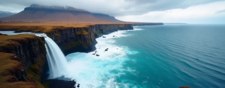
Iceland’s South Coast stands as one of the world’s most captivating natural corridors, where ancient glaciers meet volcanic black sand beaches and thundering waterfalls cascade from towering cliffs. This remarkable region stretches along the Ring Road from Reykjavik to Höfn, encompassing some of the planet’s most dramatic landscapes within a relatively compact area. The accessibility of these natural wonders makes the South Coast an ideal destination for travellers seeking to experience Iceland’s raw beauty without venturing into remote wilderness areas.
The geological forces that shaped this coastline continue their work today, creating an ever-evolving landscape where retreating glaciers reveal new valleys and volcanic activity reshapes the terrain. From the iconic waterfalls of Seljalandsfoss and Skógafoss to the ethereal beauty of Jökulsárlón glacier lagoon, each destination offers unique photographic opportunities and unforgettable experiences. The region’s popularity has grown exponentially in recent years, with visitor numbers increasing by over 300% since 2010, yet the vastness of the landscape ensures that moments of solitude remain possible for those who know where to look.
Essential route planning for iceland’s ring road south coast section
Planning your journey along Iceland’s South Coast requires careful consideration of distances, driving conditions, and seasonal variations that can significantly impact your travel experience. The Ring Road, officially known as Route 1, serves as the primary artery connecting all major South Coast attractions, but understanding the nuances of Icelandic road travel is crucial for a successful expedition.
Reykjavik to vík í mýrdal: distance and driving time calculations
The journey from Reykjavik to Vík í Mýrdal covers approximately 186 kilometres and typically requires 2.5 to 3 hours of driving time under ideal conditions. However, these calculations assume non-stop driving, which rarely reflects the reality of South Coast exploration. Most travellers allocate 6-8 hours for this route when including stops at major attractions such as Seljalandsfoss and Skógafoss waterfalls.
The route initially passes through the towns of Hveragerði and Selfoss, both offering excellent opportunities for fuel stops and refreshments. Beyond Selfoss, the landscape transforms dramatically as you enter the volcanic zones beneath Eyjafjallajökull and Katla volcanoes. Speed limits on the Ring Road typically range from 50 km/h in populated areas to 90 km/h on open stretches, though weather conditions often necessitate slower speeds.
Seasonal road conditions and F-Road access restrictions
Iceland’s volatile weather patterns create dramatically different driving conditions throughout the year, with winter months presenting particular challenges for South Coast exploration. From November through March, daylight hours are severely limited, with only 4-6 hours of usable light during the darkest period. Snow and ice frequently affect road surfaces, requiring either studded tyres or chains for safe travel.
Summer conditions from June through August offer nearly 20 hours of daylight and generally excellent road conditions, though sudden weather changes remain possible. The highland F-roads that branch off from the Ring Road typically open between late June and early September, providing access to remote areas such as Landmannalaugar and Þórsmörk valley. However, these routes require 4WD vehicles and river crossing experience.
Weather conditions in Iceland can change within minutes, transforming a clear sunny day into a fierce storm with limited visibility and dangerous driving conditions.
Petrol station locations and vehicle rental requirements
Fuel availability along the South Coast requires strategic planning, particularly when venturing beyond the Ring Road. Major petrol stations operate in Hveragerði, Selfoss, Hvolsvöllur, Vík, and Höfn, with most offering 24-hour self-service options using credit cards. However, smaller settlements may have limited operating hours or experience supply interruptions during severe weather.
Vehicle rental requirements vary significantly based on your intended routes and seasonal conditions. Standard 2WD vehicles suffice for Ring Road travel during summer months , while winter exploration demands 4WD vehicles with appropriate tyres. Many rental companies now offer vehicles equipped with GPS navigation systems specifically programmed for Icelandic conditions, including real-time weather updates and road closure information.
Accommodation booking strategies in selfoss and hvolsvöllur
Securing appropriate accommodation along the South Coast requires advance planning, particularly during peak summer months when availability becomes severely limited. Selfoss, as the largest town in the region, offers the widest selection of hotels, guesthouses, and vacation rentals, making it an ideal base for multi-day explorations. The town’s proximity to both Golden Circle attractions and South Coast highlights provides excellent flexibility for day trips.
Hvolsvöllur presents a more intimate accommodation experience, with several family-run guesthouses and the renowned Hotel Hvolsvöllur offering comfortable stays near major waterfalls. Booking accommodations 2-3 months in advance during summer ensures better selection and pricing, while winter travel often allows for more spontaneous arrangements due to reduced tourist volumes.
Iconic waterfalls and geological formations along the south coast
The South Coast’s waterfalls represent some of Iceland’s most photographed natural features, each offering unique characteristics shaped by the underlying geology and glacial meltwater sources. These cascades provide excellent examples of how Iceland’s volcanic activity and glacial processes combine to create spectacular landscapes accessible to visitors of varying physical abilities.
Seljalandsfoss Behind-the-Falls photography techniques
Seljalandsfoss offers the rare opportunity to walk behind a waterfall, creating unique photographic possibilities that require specific techniques for optimal results. The 60-metre cascade drops from the Seljalands river, creating a curtain of water that visitors can completely circumnavigate via a well-maintained path. Early morning visits between 6-8 AM provide the best lighting conditions and minimal crowds , allowing for unobstructed shots of the falls with dramatic backlighting effects.
Professional photographers recommend using a polarising filter to reduce glare from wet rocks and enhance colour saturation in the surrounding vegetation. The path behind the falls becomes slippery during wet conditions, necessitating appropriate footwear with strong grip. A waterproof camera cover proves essential, as the mist and spray can damage electronic equipment. Wide-angle lenses capture the full scope of the falls and surrounding cliffs, while longer focal lengths isolate specific elements of the cascade for detailed compositions.
Skógafoss rainbow formation and climbing trail access
Skógafoss presents one of Iceland’s most powerful waterfalls, dropping 60 metres with a width of 25 metres that creates substantial mist clouds ideal for rainbow formation. The phenomenon occurs most frequently during sunny conditions between 11 AM and 3 PM, when solar angle and mist density combine optimally. Multiple rainbows often appear simultaneously, creating spectacular photographic opportunities for those positioned correctly relative to the sun and falls.
The eastern side of Skógafoss features a steep staircase with over 500 steps leading to the top of the falls and the beginning of the Fimmvörðuháls hiking trail. This challenging ascent rewards visitors with panoramic views across the South Coast and access to numerous smaller waterfalls along the Skógá river. The trail continues for 25 kilometres to Þórsmörk valley , passing between the Eyjafjallajökull and Mýrdalsjökull glaciers through some of Iceland’s most pristine highland scenery.
Gljúfrabúi hidden canyon navigation and safety protocols
Gljúfrabúi, located approximately 600 metres north of Seljalandsfoss, requires careful navigation through a narrow canyon entrance that conceals one of Iceland’s most atmospheric waterfalls. The approach involves wading through shallow water and negotiating slippery rocks within a confined space where the waterfall drops 40 metres into a circular chamber. Proper preparation and safety awareness are essential for accessing this hidden gem.
Waterproof footwear with excellent grip becomes mandatory for safe canyon navigation, as the rocks remain continuously wet from waterfall spray. The confined space can become congested during peak visitation periods, requiring patience and courtesy when moving through the narrow passages. Photography within the canyon demands careful protection of equipment, as the enclosed space intensifies mist and spray effects compared to open waterfalls.
Svartifoss basalt column photography at skaftafell national park
Svartifoss, the “Black Waterfall,” cascades over spectacular hexagonal basalt columns that inspired the architectural design of Reykjavik’s Hallgrímskirkja church. Located within Skaftafell National Park, this 20-metre waterfall requires a 1.5-kilometre hike from the visitor centre, gaining approximately 100 metres of elevation through diverse terrain including birch woodlands and glacial moraines.
The basalt columns surrounding Svartifoss formed through slow cooling of lava flows, creating the distinctive geometric patterns that provide dramatic contrast against the white cascade. Late afternoon lighting enhances the texture and colour variations in the basalt formations , while the surrounding vegetation adds seasonal colour elements ranging from bright green summer foliage to golden autumn tones. Macro photography techniques capture the intricate details of individual basalt segments, while wide compositions emphasise the waterfall’s dramatic setting within the broader Skaftafell landscape.
Glacier exploration and ice cave adventures
Iceland’s South Coast provides unparalleled access to some of Europe’s largest glaciers, offering visitors opportunities to experience these ancient ice formations through guided expeditions and specialised tours. The region’s glacial landscapes continue evolving due to climate change, creating both new exploration opportunities and emphasising the urgency of experiencing these natural wonders while they remain accessible.
Sólheimajökull glacier tongue guided hiking expeditions
Sólheimajökull represents one of Iceland’s most accessible glacier tongues, extending from the larger Mýrdalsjökull ice cap to within walking distance of the Ring Road. This outlet glacier provides an ideal introduction to glacier hiking, with guided expeditions suitable for participants with moderate fitness levels and no previous glacial experience. The glacier’s surface features crevasses, seracs, and moulins that demonstrate the dynamic nature of glacial ice movement.
Professional guides provide all necessary safety equipment including crampons, helmets, and ice axes, while explaining glacial formation processes and the impacts of climate change on ice retreat. The glacier has receded significantly in recent decades, with the terminus now located approximately 1 kilometre further inland than in 1990. Guided tours typically last 3-4 hours and operate year-round , though winter expeditions require additional cold weather preparations and shorter daylight hours limit available departure times.
Vatnajökull national park ice cave seasonal accessibility
The ice caves within Vatnajökull National Park represent some of the world’s most spectacular natural ice formations, created by geothermal activity and meltwater flow beneath Europe’s largest glacier. These caves form and collapse continuously, creating an ever-changing underground landscape of crystalline blue ice chambers and tunnels. Access to ice caves requires professional guides with extensive local knowledge, as conditions change rapidly and safety risks include unstable ice formations and changing weather patterns.
Natural ice caves typically become accessible from November through March, when freezing temperatures stabilise the ice structures sufficiently for safe exploration. The most famous caves include the Crystal Cave and various unnamed formations that guides discover and assess throughout the season. Artificial ice caves created in stable glacier locations provide year-round access , though they lack the ethereal beauty and natural formation processes of their seasonal counterparts.
Ice cave exploration represents one of the most unique experiences available anywhere in the world, offering access to ancient ice formations that have developed over centuries of glacial activity.
Jökulsárlón glacier lagoon zodiac boat tours
Jökulsárlón glacier lagoon has evolved from a small glacial pool in the 1930s to Iceland’s deepest lake, reaching depths exceeding 250 metres as the Breiðamerkurjökull glacier continues retreating. The lagoon fills with icebergs calved from the glacier terminus, creating a constantly changing seascape of floating ice sculptures in various shades of blue and white. Zodiac boat tours provide intimate access to these icebergs while maintaining safe distances from unstable ice formations.
Amphibian boat tours operate from May through October, offering 30-40 minute excursions among the icebergs with opportunities to observe Arctic seals that frequently haul out on ice floes. The lagoon connects to the ocean through a short channel, allowing icebergs to drift seaward where they may wash ashore on Diamond Beach. Water temperatures in the lagoon remain near freezing year-round, creating challenging conditions for wildlife while preserving the ice formations for extended periods.
Diamond beach icebergs and breiðamerkursandur black sand analysis
Diamond Beach earns its name from the crystalline icebergs that wash ashore on Breiðamerkursandur’s black volcanic sand, creating striking visual contrasts between translucent ice and dark basaltic material. These icebergs originate from Jökulsárlón lagoon, drifting through the connecting channel to the Atlantic Ocean before being deposited on the beach by wave action. The beach extends for several kilometres, providing numerous viewing points and photographic opportunities.
The black sand composition reflects the volcanic origins of the South Coast, consisting primarily of basaltic minerals ground down by glacial action and wave erosion over thousands of years. Iceberg sizes on Diamond Beach range from small fragments to massive blocks exceeding 3 metres in height , with their persistence depending on air temperature, wave action, and solar radiation. The beach presents safety considerations including unpredictable waves and slippery conditions around ice formations, requiring visitors to maintain appropriate distances from the surf zone.
Volcanic landscapes and black sand beach exploration
The South Coast’s volcanic heritage creates some of Earth’s most dramatic coastal landscapes, where active volcanic systems beneath massive ice caps have shaped the terrain through explosive eruptions and glacial floods. The region sits atop the Mid-Atlantic Ridge, where ongoing tectonic activity continues reshaping the landscape through volcanic processes that have operated for millions of years. These geological forces create the distinctive black sand beaches, columnar basalt formations, and lava fields that characterise the South Coast’s unique aesthetic.
Reynisfjara black sand beach near Vík represents the most famous example of volcanic coastal formation, where basaltic sea cliffs meet the North Atlantic through dramatic wave-cut platforms and sea stacks. The beach’s Garðar basalt columns demonstrate the geometric patterns created when lava cools slowly, forming hexagonal structures that extend both above and below sea level. The offshore Reynisdrangar sea stacks rise 66 metres above the waves, composed of the same volcanic rock that underlies the entire coastal region.
Dyrhólaey arch provides spectacular viewing opportunities across these volcanic landscapes, rising 120 metres above sea level to offer panoramic perspectives of the coastline stretching toward Vatnajökull glacier. The arch itself formed through marine erosion of volcanic rock, creating a 20-metre opening through which smaller boats can pass during calm conditions. The area serves as a crucial nesting site for numerous seabird species , including puffins, guillemots, and arctic terns that utilise the cliff faces for breeding colonies between May and September.
The Eldhraun lava field, visible from elevated viewpoints along the Ring Road, represents one of the largest lava flows in recorded human history, created during the catastrophic Laki eruption of 1783-1784. This eruption produced devastating global climate impacts, contributing to famine across Europe and affecting weather patterns worldwide. Today, the lava field supports extensive moss coverage that creates an otherworldly green carpet across the hardened basaltic surface, demonstrating nature’s capacity for regeneration following volcanic devastation.
The interplay between volcanic activity and glacial processes along Iceland’s South Coast creates landscapes found nowhere else on Earth, where fire and ice collaborate to produce extraordinary natural sculptures.
Safety considerations for beach exploration include awareness of dangerous wave conditions, particularly the unpredictable “sneaker waves” that can surge much farther inland than normal wave patterns suggest. These powerful waves have resulted in several fatalities at Reynisfjara, emphasising the importance of maintaining safe distances from the water’s edge and heeding posted warning signs. The volcanic sand also creates challenging walking conditions, particularly when wet, and can damage electronic equipment through fine particle infiltration.
Wildlife watching and puffin colony locations
Iceland’s South Coast supports diverse wildlife populations that have adapted to the region’s unique environmental conditions, from arctic se
als resting on icebergs in Jökulsárlón lagoon to vast seabird colonies nesting along dramatic cliff faces. The region’s position along major migration routes and the abundance of marine food sources create ideal conditions for observing both resident and seasonal wildlife populations throughout the year.
Arctic seals represent the most commonly observed marine mammals along the South Coast, with harbour seals and grey seals frequently visible in Jökulsárlón glacier lagoon and coastal waters near Vík. These adaptable marine mammals have learned to utilise floating icebergs as resting platforms, allowing close observation during boat tours while maintaining safe distances. Seal populations peak during summer months when abundant fish stocks and extended daylight hours create optimal feeding conditions.
The dramatic sea cliffs between Dyrhólaey and the Westman Islands support some of Iceland’s largest seabird colonies, with over 60 species documented in the region. Puffin colonies reach their peak activity between June and mid-August, when approximately 10,000 breeding pairs establish nests in the grassy cliff tops around Dyrhólaey. These charismatic seabirds arrive in late April to establish territories and depart by early September, timing their breeding cycle to coincide with peak fish availability.
Reynisfjara’s basalt columns provide nesting sites for guillemots, razorbills, and kittiwakes, creating spectacular viewing opportunities for wildlife photographers equipped with telephoto lenses. The black sand beach below often reveals evidence of seabird activity through feathers, eggshells, and feeding remains deposited by wave action. Northern fulmars glide along the cliff faces throughout the year, demonstrating remarkable aerial agility as they navigate the turbulent air currents created by the coastal topography.
The South Coast’s wildlife viewing opportunities change dramatically with the seasons, from summer’s explosive seabird activity to winter’s focus on marine mammals and occasional arctic fox sightings.
Whale watching opportunities exist throughout the coastal waters, with minke whales, white-beaked dolphins, and harbour porpoises frequently observed from elevated viewpoints along the Ring Road. Orcas occasionally appear near Diamond Beach and Jökulsárlón, particularly during herring migrations in spring and autumn. The deep waters offshore support larger cetacean species including humpback and fin whales, though these require dedicated boat tours from Reykjavík for reliable observation opportunities.
Arctic foxes inhabit the remote areas around Skaftafell National Park, though sightings remain challenging due to their elusive nature and excellent camouflage. These adaptable predators have learned to exploit seabird colonies during breeding season while maintaining year-round territories in the harsh highland environment. Winter observations become more likely as foxes venture closer to human settlements in search of food sources during periods of snow cover.
Adventure activities and extreme sports opportunities
Iceland’s South Coast has evolved into one of the world’s premier adventure sports destinations, where the dramatic landscape provides natural venues for activities ranging from glacier mountaineering to volcanic cave exploration. The region’s accessibility combined with professional guide services allows visitors to safely experience extreme environments that would otherwise remain off-limits to recreational adventurers.
Ice climbing represents the pinnacle of South Coast adventure activities, with frozen waterfalls and glacial formations providing routes suitable for all skill levels. Sólheimajökull glacier offers beginner-friendly ice climbing experiences under professional instruction, while advanced climbers can tackle the challenging ice formations around Skaftafell National Park. Winter conditions from December through March create the most stable ice climbing opportunities, though artificial ice walls constructed near Vík provide year-round access for skill development.
Glacier kayaking in Jökulsárlón lagoon combines paddling skills with wildlife observation as adventurers navigate between massive icebergs while maintaining awareness of changing weather conditions and ice movement. These guided expeditions require previous kayaking experience and provide specialised dry suits to protect against the near-freezing water temperatures. The unique perspective from water level reveals details of iceberg structure and coloration invisible from shore-based observation points.
Volcano boarding and lava tube exploration offer adrenaline-filled encounters with Iceland’s volcanic heritage through activities impossible elsewhere on Earth. The dormant craters around Eyjafjallajökull provide steep slopes suitable for volcano boarding, where participants descend volcanic scree fields on specially designed boards at speeds exceeding 40 kilometres per hour. Underground lava tube networks near Hvolsvöllur create labyrinthine cave systems perfect for spelunking adventures that reveal the internal structure of ancient lava flows.
Snowmobiling across Mýrdalsjökull glacier provides access to remote ice cap regions otherwise unreachable except by experienced mountaineers with specialised equipment. These high-speed expeditions cover vast distances across pristine snow fields while offering panoramic views of the surrounding volcanic landscape and distant mountain ranges. Professional guides navigate crevasse fields and changing weather conditions while maintaining radio contact with base stations for safety monitoring.
The South Coast’s adventure activities operate within one of Earth’s most dynamic environments, where volcanic activity, glacial movement, and extreme weather create constantly changing conditions that demand respect and proper preparation.
Paragliding and hang-gliding take advantage of the dramatic elevation changes between glacial highlands and coastal lowlands, with launch sites near Skaftafell providing optimal conditions for extended flights. The thermal currents generated by temperature contrasts between ice fields and dark volcanic surfaces create excellent lift conditions for experienced pilots. These aerial activities require advanced certification and local weather expertise due to the unpredictable wind patterns common in glacial environments.
Rock climbing opportunities abound throughout the basalt cliff systems, from the accessible routes around Reynisfjara to the challenging multi-pitch ascents available in Fjaðrárgljúfur canyon. The volcanic rock provides excellent grip characteristics when dry, though frequent precipitation and coastal spray create challenging conditions requiring specialised equipment and techniques. Local climbing guides possess essential knowledge of route conditions, weather patterns, and emergency evacuation procedures necessary for safe exploration.
Highland hiking and trekking expeditions venture beyond the accessible Ring Road attractions to explore remote valleys, hidden hot springs, and pristine wilderness areas accessible only on foot. The Laugavegur trail connects the South Coast to Iceland’s highland interior through some of the country’s most spectacular and challenging terrain. Multi-day expeditions require careful planning for river crossings, weather changes, and emergency communications in areas where rescue operations become complex and time-consuming.
Extreme weather photography workshops capitalise on the South Coast’s reputation for dramatic atmospheric conditions, teaching participants to safely capture images during storms, aurora displays, and rapidly changing light conditions. These specialised courses combine technical photography instruction with wilderness survival skills necessary for working in harsh environmental conditions. Professional instructors provide insights into weather prediction, equipment protection, and composition techniques specific to Iceland’s challenging photographic environments.
