The Bahamas archipelago, with its 700 islands and 2,400 cays scattered across crystalline Atlantic waters, presents one of the world’s premier island-hopping destinations. This vast maritime playground stretches over 100,000 square miles, offering experienced travellers an intricate network of shallow-water channels, secluded anchorages, and diverse cultural experiences that few other destinations can match. The art of island hopping here requires more than simply moving between landmasses; it demands understanding tidal patterns, weather systems, and the unique characteristics that make each island distinct.
Mastering the Bahamian archipelago means embracing both spontaneity and meticulous planning. The shallow banks that characterise these waters create stunning turquoise lagoons but also present navigation challenges that separate novice visitors from seasoned explorers. Success in these waters comes from understanding that each island cluster has its own personality, from the sophisticated resort culture of Nassau and Paradise Island to the untouched wilderness of the southern Out Islands.
Strategic Inter-Island navigation planning for the bahamian archipelago
Effective navigation through the Bahamas requires understanding the archipelago’s natural divisions and transportation networks. The island chains are separated by deep ocean trenches, creating distinct geographical regions that influence weather patterns, marine life, and cultural development. Strategic route planning considers these natural barriers alongside practical factors such as fuel availability, customs clearance points, and seasonal weather patterns.
The most successful island hoppers develop flexible itineraries that account for the unpredictable nature of Caribbean weather systems. Trade winds, tropical storms, and seasonal current changes can dramatically affect travel times and safety conditions. Professional mariners recommend maintaining alternative routes for each planned segment, ensuring that weather delays don’t derail entire expeditions.
The key to successful Bahamian island hopping lies not in rigid scheduling, but in understanding the rhythm of the islands themselves and adapting your journey accordingly.
Nassau-paradise island hub selection for Multi-Island access
Nassau serves as the natural starting point for most archipelago explorations, offering comprehensive marine services, customs facilities, and the largest selection of charter vessels in the Bahamas. The harbour infrastructure supports everything from small motorboats to superyachts, with fuel docks, provisioning services, and experienced local pilots available for hire. Paradise Island’s Hurricane Hole Superyacht Marina provides state-of-the-art facilities specifically designed for larger vessels planning extended cruising programmes.
The strategic advantage of Nassau lies in its central location relative to major island chains. From here, the Exuma Cays lie 35 nautical miles southeast, the Berry Islands 30 miles north, and Eleuthera 60 miles east. This positioning allows for efficient hub-and-spoke routing or linear progressions depending on your preferred exploration style. Weather monitoring services and marine forecasting are readily available, enabling informed decision-making for departure timing.
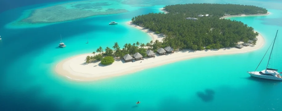
Exuma cays chain routing via staniel cay and iguana beach
The Exuma Cays represent the crown jewel of Bahamian island hopping, offering 365 individual islands stretching 120 miles southeast from Nassau. Staniel Cay serves as the unofficial capital of this chain, providing fuel, provisions, and the famous Thunderball Grotto snorkelling site. The cay’s yacht club and restaurant create a social hub where experienced cruisers share local knowledge and weather updates.
Navigation through the Exuma Cays requires careful attention to the numerous shallow banks and coral heads that dot the region. The protected waters of the Exuma Cays Land and Sea Park offer some of the most pristine marine environments in the Caribbean, but also enforce strict anchoring regulations designed to protect fragile coral formations. Experienced navigators recommend using GPS chartplotters combined with visual piloting techniques, as satellite imagery often provides clearer guidance than traditional nautical charts in these shallow waters.
Andros island western route integration with berry islands
Andros Island, the largest landmass in the Bahamas, offers a dramatically different island-hopping experience focused on wilderness exploration and deep-water fishing. The western approach via the Berry Islands provides excellent staging for Andros exploration while offering some of the archipelago’s best game fishing opportunities. The Berry Islands chain consists of 30 individual cays, many privately owned, creating an exclusive atmosphere favoured by discerning travellers.
The transition from the Berry Islands to Andros involves crossing the Tongue of the Ocean, a deep-water trench that drops to over 6,000 feet. This crossing offers opportunities for blue water fishing but requires careful weather planning due to the exposure to ocean swells and wind-driven seas. The western coast of Andros features numerous creek systems and blue holes that provide sheltered anchorages and world-class diving opportunities.
Abacos island chain northern circuit planning
The Abacos represent the sailing capital of the Bahamas, with consistent trade winds, numerous marinas, and a well-established cruising community. The northern circuit begins in Marsh Harbour, the third-largest city in the Bahamas, and progresses through Hope Town, Man-O-War Cay, and Green Turtle Cay. Each settlement maintains its own distinct character, from the candy-coloured houses of Hope Town to the boat-building traditions of Man-O-War Cay.
The Sea of Abaco provides protected waters ideal for learning advanced sailing techniques or enjoying leisurely day sails between settlements. The predictable wind patterns and numerous anchorages make this region particularly suitable for families or less experienced mariners looking to develop their island-hopping skills. Local ferry services connect the major settlements, providing backup transportation options for those travelling on smaller vessels.
Out islands logistics for cat island and san salvador
The Out Islands, including Cat Island and San Salvador, represent the frontier of Bahamian island hopping, requiring advanced planning and self-sufficiency. These remote destinations offer minimal marine infrastructure, making fuel planning and provisions management critical success factors. Cat Island, in particular, stretches 48 miles in length but offers only a few small settlements with basic services.
San Salvador holds historical significance as Christopher Columbus’s first landfall in the New World, but accessing this remote island requires careful weather planning due to its exposed position in the Atlantic. The island’s diving opportunities, including pristine wall diving and shark encounters, reward the effort required to reach these waters. Logistical planning for Out Islands exploration should include emergency communication equipment, extended fuel reserves, and comprehensive medical supplies.
Charter vessel selection and maritime transport optimization
Selecting the appropriate vessel for Bahamian island hopping significantly impacts both safety and enjoyment throughout your expedition. The unique characteristics of Bahamian waters, particularly the extensive shallow banks and coral formations, demand specific vessel attributes that may differ from those suitable for other cruising destinations. Understanding these requirements before committing to a charter can mean the difference between a successful adventure and a frustrating series of limitations.
The charter market in the Bahamas offers diverse options ranging from bareboat sailing yachts to fully crewed superyachts, each presenting distinct advantages for different types of exploration. Market trends indicate increasing demand for vessels specifically designed for shallow-water cruising, reflecting the growing sophistication of charterers seeking to access remote anchorages and pristine snorkelling sites that remain inaccessible to deeper-draft vessels.
Catamaran charter specifications for shallow draft navigation
Catamarans have revolutionised Bahamian island hopping due to their shallow draft characteristics, typically drawing just 3-4 feet compared to 6-8 feet for equivalent monohull sailing yachts. This advantage enables access to countless secluded anchorages, pristine beaches, and shallow lagoons that remain off-limits to conventional vessels. Modern charter catamarans also offer superior stability and spacious deck areas, enhancing comfort during extended anchoring periods.
The twin-hull design provides redundancy in both propulsion and steering systems, increasing safety margins when navigating through coral-studded waters. Leading charter operators now specify catamarans with lifting keels or dagger boards, further reducing draft to less than 3 feet when retracted. These vessels typically feature mesh trampolines between the hulls, creating additional outdoor living space that proves invaluable during tropical weather conditions.
Seaplane services via bahamas air sea rescue association routes
Seaplane services offer unparalleled flexibility for accessing remote settlements and private islands throughout the archipelago. These aircraft can land on any reasonably protected water surface, enabling connections to destinations completely inaccessible by conventional transportation. The Bahamas Air Sea Rescue Association maintains detailed information on suitable landing areas, weather conditions, and emergency protocols specific to seaplane operations.
Charter seaplane services typically operate from Nassau, Marsh Harbour, and Georgetown, with experienced pilots familiar with local wind patterns, tidal conditions, and marine traffic. The aerial perspective provided during seaplane flights also offers valuable reconnaissance for subsequent vessel-based exploration, allowing identification of promising anchorages and snorkelling sites from above. Flight duration between most island pairs ranges from 15-45 minutes, dramatically reducing travel time compared to surface vessels.
Private yacht mooring at marina facilities in georgetown
Georgetown, located on Great Exuma, serves as the southern gateway to the Exuma Cays and provides essential services for yachts exploring the southern archipelago. The town’s marina facilities have expanded significantly in recent years, now accommodating vessels up to 150 feet in length with full utility connections and provisioning services. The annual Georgetown Cruising Regatta attracts hundreds of cruising yachts, creating a vibrant community atmosphere during the winter season.
The marina’s strategic location provides access to numerous day-trip destinations, including the famous swimming pigs of Big Major Cay and the iguanas of Bitter Guana Cay. Fuel dock facilities operate extended hours during peak season, and local mechanics specialise in marine diesel engines and sail repair services. The surrounding waters offer excellent holding ground in sand and grass, with numerous anchorages suitable for vessels of all sizes.
Mail boat schedule coordination with nassau harbour departures
The traditional mail boat service represents an authentic Bahamian transportation method that continues to connect remote settlements with Nassau’s commercial centre. These vessels operate on predictable schedules, typically departing Nassau on specific weekdays and returning several days later with passengers, cargo, and mail. Understanding these schedules provides backup transportation options and insight into local supply chains that influence provisioning availability on remote islands.
Mail boat routes serve destinations throughout the archipelago, including settlements accessible only by these traditional vessels. The boats themselves offer cultural experiences, with local passengers, livestock, and diverse cargo creating a authentic slice of Bahamian life. Coordination with mail boat schedules can be particularly valuable for crew changes, emergency transportation, or accessing islands where private yacht anchoring may be restricted or impractical.
Tidal navigation and shallow water channel management
Mastering tidal navigation in the Bahamas requires understanding the complex interaction between Atlantic Ocean tides, shallow banks, and numerous islands that create localised tidal variations throughout the archipelago. Unlike deeper ocean environments where tidal changes primarily affect vertical water levels, Bahamian shallow banks experience dramatic horizontal tidal flows that can create or eliminate navigable channels within hours. The tidal range varies from 2-4 feet depending on location and lunar cycle, but the horizontal displacement of water can extend for miles across extensive shallow areas.
Successful shallow-water navigation combines traditional seamanship with modern technology, utilising GPS chartplotters, depth sounders, and visual piloting techniques simultaneously. The crystal-clear water that makes the Bahamas so visually stunning also provides excellent visibility of bottom conditions, enabling experienced navigators to identify sand, grass, coral, and rock substrates that indicate water depth and safe passage routes. Satellite imagery has become an invaluable tool, often showing shallow areas and channels more clearly than traditional nautical charts.
Current patterns in the Bahamas create additional complexity, with tidal flows often concentrated through narrow passages between islands, creating venturi effects that increase current speeds dramatically. These concentrated flows can exceed 3 knots in passages like Current Cut between Eleuthera and Current Island, requiring careful timing for safe transit. Understanding these patterns enables experienced island hoppers to use tidal assistance for efficient passage-making while avoiding dangerous conditions during opposing tides.
Channel management becomes particularly critical when approaching anchorages or marina facilities during different tidal states. Many popular destinations have controlling depths that may become impassable during low tide periods, making arrival timing crucial for vessel safety. Local knowledge from marina operators, other cruisers, and fishing guides proves invaluable for understanding specific channel characteristics and optimal transit times.
Advanced snorkelling and diving site identification
The Bahamas offers some of the world’s most diverse underwater environments, from shallow coral gardens to vertical wall dives plunging thousands of feet into oceanic depths. Identifying premium snorkelling and diving sites requires understanding the geological processes that created the archipelago’s unique underwater topography. The Bahamas Bank, a massive shallow-water platform, creates distinct zones of marine habitat that support different species communities and offer varied underwater experiences.
Water clarity throughout the archipelago typically exceeds 100 feet visibility, enabling underwater photography and marine life observation under optimal conditions. The warm Gulf Stream temperatures maintain year-round water temperatures between 72-84°F, supporting tropical marine ecosystems while remaining comfortable for extended underwater activities. Seasonal variations in marine life populations create opportunities to target specific species encounters, from winter humpback whale migrations to summer spawning aggregations of various fish species.
Thunderball grotto cave system navigation techniques
Thunderball Grotto, located near Staniel Cay in the Exumas, represents one of the world’s most accessible underwater cave systems, featuring a partially submerged limestone cavern filled with tropical fish. The grotto’s unique structure allows natural light to filter through underwater openings, creating cathedral-like lighting effects that make it a favourite among underwater photographers. Navigation within the grotto requires understanding tidal flows and surge patterns that affect entry and exit safety.
The grotto’s multiple entrances accommodate snorkellers of varying experience levels, with the largest opening requiring only a 3-foot dive to access the interior chamber. Inside, the cavern opens into a spacious underwater room where tropical fish congregate in dense schools, creating spectacular viewing opportunities. Advanced snorkellers can explore secondary chambers and passages, though these areas require greater breath-holding ability and underwater navigation skills.
Dean’s blue hole freediving protocols in long island
Dean’s Blue Hole on Long Island holds the record as the world’s deepest known blue hole, plunging 663 feet into the earth’s crust through a perfectly circular opening 80 feet in diameter. This geological wonder attracts world-class freedivers and technical divers, but accessing its depths safely requires strict adherence to established safety protocols and advanced diving qualifications. The site’s remote location demands complete self-sufficiency and emergency preparedness.
The blue hole’s unique characteristics include a thermocline at approximately 100 feet where water temperature drops dramatically, and haloclines where saltwater and freshwater layers create visual distortions. These environmental factors affect buoyancy, visibility, and physiological responses during deep dives. Safety protocols mandate buddy diving, surface support personnel, and emergency oxygen availability for all activities beyond recreational snorkelling depths.
Coral reef preservation protocols at andros barrier reef
The Andros Barrier Reef, stretching 140 miles along Andros Island’s eastern coast, represents the third-largest barrier reef system in the world and requires careful preservation protocols to maintain its ecological integrity. The reef system supports over 164 fish species and numerous coral varieties, many endemic to Bahamian waters. Established protocols emphasise no-anchor zones, minimum distance requirements from coral formations, and restrictions on fish feeding activities.
Diving and snorkelling activities within the reef system follow internationally recognised guidelines for coral reef interaction, including prohibitions on coral touching, collection of marine specimens, and use of harmful sunscreen chemicals. The reef’s structure includes numerous blue holes and inland lakes connected to the ocean through underground cave systems, creating unique diving opportunities that require specialised training and equipment. Marine park regulations enforce strict penalties for coral damage, making adherence to preservation protocols both an ethical and legal requirement.
Shark diving operations at tiger beach in grand bahama
Tiger Beach, located 20 miles off Grand Bahama’s coast, has gained international recognition as one of the world’s premier shark diving destinations, regularly hosting encounters with Caribbean reef sharks, nurse sharks, and the occasional tiger shark. Professional diving operations at this site follow strict safety protocols developed through years of experience with large predator encounters. These protocols include mandatory briefings, specialised equipment requirements, and experienced dive guides familiar with local shark behaviour patterns.
The site’s unique characteristics include a sandy bottom at 25 feet depth that provides excellent visibility and allows sharks to approach closely without feeling threatened by overhead cover
. Professional operators use specialised cages and positioning systems that allow divers to maintain safe distances while observing natural behaviours. Surface support boats remain in constant communication with underwater teams, monitoring weather conditions and marine traffic that could affect dive safety.
The diving season at Tiger Beach extends from October through April when water temperatures and visibility reach optimal levels. Advanced open water certification represents the minimum requirement for participation, though most operators recommend deep-water experience and comfort with large marine life encounters. Underwater photographers particularly value this site for its combination of large pelagic species and excellent lighting conditions created by the sandy bottom and clear water column.
Weather pattern analysis and seasonal route adaptation
Understanding Bahamian weather patterns requires recognising the complex interaction between the Gulf Stream, trade wind systems, and seasonal pressure changes that affect the entire archipelago. The region experiences distinct wet and dry seasons, with hurricane season extending from June through November creating additional planning considerations for extended cruising expeditions. Trade winds typically blow from the northeast during winter months, shifting to southeast during summer, fundamentally altering optimal sailing routes and anchoring strategies throughout the year.
Successful island hoppers develop season-specific routing strategies that account for prevailing wind directions, storm tracks, and local weather phenomena unique to different regions of the archipelago. The shallow banks that characterise much of the Bahamas create localised weather effects, including accelerated winds over shallow areas and calm conditions in the lee of larger islands. Cold front passages during winter months can create dangerous conditions on the banks, with steep waves developing rapidly in shallow water when strong winds oppose tidal currents.
Modern weather routing incorporates satellite imagery, surface analysis charts, and localised reporting stations throughout the archipelago. The automated weather stations on key islands provide real-time wind, wave, and barometric pressure data essential for passage planning. Professional mariners recommend maintaining multiple weather information sources and developing contingency plans for each leg of extended cruising itineraries.
Seasonal route adaptation becomes particularly important when planning transitions between different island groups. The crossing from Nassau to the Abacos, for example, requires different timing and routing strategies depending on season, with winter cold fronts making northern routes more challenging while summer tropical activity may affect southern passages. Experienced navigators often maintain seasonal base locations, spending winter months in the central or southern Bahamas while relocating north during hurricane season for enhanced protection and maintenance opportunities.
Cultural immersion strategies in traditional settlements
Authentic cultural experiences in the Bahamas extend far beyond resort activities, requiring genuine engagement with traditional settlements where generations of Bahamian families maintain customs, crafts, and social traditions largely unchanged for decades. These communities offer insights into the complex cultural heritage that blends African, British, American, and indigenous Lucayan influences into the distinctive Bahamian identity. Successful cultural immersion requires approaching these communities with respect, genuine interest, and understanding of local customs and social protocols.
Traditional settlements throughout the Out Islands maintain economies based on fishing, farming, and traditional crafts that provide authentic glimpses into pre-tourism Bahamian life. Many settlements welcome respectful visitors, particularly those arriving by private vessel who demonstrate commitment to experiencing local culture beyond casual day-trip activities. Building relationships within these communities often requires multiple visits and demonstrated respect for local customs and environmental concerns.
Junkanoo festival participation in harbour island
Junkanoo represents the most vibrant expression of Bahamian cultural identity, combining African rhythmic traditions with colourful costumes, competitive group performances, and community-wide celebration that transforms entire settlements during festival periods. Harbour Island’s Junkanoo celebrations maintain intimate, community-focused character distinct from Nassau’s large-scale tourist productions. Participation requires advance planning, as costume creation and rehearsals begin months before actual festival dates.
The festival’s musical elements feature traditional instruments including goatskin drums, cowbells, and whistles creating complex polyrhythmic patterns that drive hours-long processions through settlement streets. Local groups compete in categories including music, costume design, and choreography, with judging based on traditional criteria maintained by community elders. Visitors seeking authentic participation should contact local group leaders well in advance, as genuine involvement requires commitment to rehearsal schedules and costume preparation activities.
Harbour Island’s festival schedule includes Boxing Day and New Year’s Day celebrations, with additional events during summer festivals and special commemorations. The island’s compact size creates intimate viewing conditions where visitors can observe intricate costume details and interact directly with performers between competitive segments. Cultural protocols emphasise respectful observation, appropriate photography permissions, and understanding that Junkanoo represents serious cultural expression rather than entertainment staged for tourists.
Conch bar cave exploration protocols in middle caicos
The extensive cave systems of Middle Caicos provide unique opportunities for underground exploration within formations that extend for miles beneath the island’s limestone foundation. Conch Bar Caves represent the largest cave system in the Bahamas, featuring spectacular stalactite and stalagmite formations, underground lakes, and historical significance as shelter locations during hurricanes and conflicts. Exploration requires specific safety protocols and respect for the fragile geological formations that require thousands of years to develop.
Local guides from Middle Caicos possess generational knowledge of cave systems, including safe routes, historical significance, and ecological considerations essential for responsible exploration. These guides often share oral histories connecting cave usage to settlement patterns, hurricane survival strategies, and traditional resource management practices. The cave systems also support unique ecosystems, including endemic bat species and specialized invertebrates adapted to underground environments.
Proper cave exploration equipment includes reliable lighting systems, protective helmets, and appropriate footwear for navigating uneven limestone surfaces. The caves maintain constant temperatures and humidity levels that support delicate formations easily damaged by touching or inappropriate lighting. Visitors should follow established pathways, avoid disturbing wildlife, and understand that some areas remain restricted to protect both geological formations and visitor safety.
Rake and scrape music sessions in cat island communities
Cat Island maintains the strongest traditions of rake and scrape music, the indigenous Bahamian musical form that predates modern recorded music and continues to provide social cohesion within traditional communities. This acoustic music tradition utilises handmade instruments including the saw, washboard, and various percussion elements to create distinctive rhythmic patterns that accompany traditional dances and social gatherings. Participating in authentic rake and scrape sessions requires invitation from community members and respect for the social protocols surrounding these musical traditions.
The music sessions typically occur during community celebrations, family gatherings, and traditional holidays when multiple generations come together to maintain cultural continuity. Younger community members learn traditional songs and rhythmic patterns through direct participation rather than formal instruction, ensuring authentic transmission of musical knowledge. These sessions often continue for hours, with different community members contributing vocals, instruments, and traditional dances that reflect the music’s social function.
Cat Island’s remote location and limited tourism development have preserved these traditions more completely than in other Bahamian islands where commercial influences have modified traditional cultural expressions. Villages like Old Bight and Knowles maintain regular music sessions where visitors may be welcomed if introduced properly by community members. Cultural sensitivity requires understanding that these sessions serve important social functions beyond entertainment, including conflict resolution, community bonding, and cultural education for younger generations.
Traditional fishing village interactions in spanish wells
Spanish Wells represents one of the most successful traditional fishing communities in the Caribbean, maintaining economic independence through sustainable fishing practices while preserving distinctive cultural traditions dating to the original Loyalist settlers. The community’s success in commercial fishing, particularly lobster harvesting, provides insights into traditional maritime skills, sustainable resource management, and the social structures that enable small island communities to thrive in the modern economy.
The island’s unique demographic composition, with residents primarily descended from Loyalist families who arrived in the 1780s, has created a distinctive cultural identity that blends British maritime traditions with Bahamian adaptations. Traditional boat building techniques, passed through family generations, produce the distinctive Bahamian sloops and fishing vessels specifically designed for local conditions. These skills remain economically vital, as locally built vessels continue to outperform imported alternatives for specific fishing applications.
Visiting fishing vessels can often arrange to accompany local boats on fishing expeditions, providing direct experience with traditional fishing techniques, local knowledge of marine ecosystems, and insights into the economic challenges facing traditional maritime communities. The community’s fishing cooperative demonstrates successful local resource management, with sustainable practices that have maintained lobster populations while supporting community prosperity. Respectful interaction requires understanding the community’s work schedules, religious observances, and preference for visitors who demonstrate genuine interest in maritime traditions rather than casual tourism activities.
