The Canadian Rockies stand as one of Earth’s most spectacular mountain ranges, stretching across western Canada like a granite spine of unparalleled natural beauty. These towering peaks, carved by millions of years of geological forces, create a landscape that captivates nature enthusiasts from around the globe. From the turquoise waters of glacial lakes to the pristine wilderness areas where grizzly bears roam freely, the Canadian Rockies offer an extraordinary tapestry of ecosystems that showcase the raw power and delicate balance of nature. The region encompasses five national parks and numerous provincial parks, protecting over 23,000 square kilometres of pristine mountain wilderness where ancient glaciers continue their slow retreat and endemic species thrive in specialized alpine environments.
Geological formation and tectonic history of the canadian rockies
The Canadian Rockies represent a geological masterpiece that took over 600 million years to create, showcasing some of the most dramatic examples of tectonic forces on Earth. Understanding the complex geological history of this region reveals why these mountains possess such distinctive characteristics and why they continue to attract geologists and nature lovers alike.
Paleozoic sedimentary rock layers and marine fossil deposits
During the Paleozoic Era, approximately 540 to 252 million years ago, the area now occupied by the Canadian Rockies lay beneath a vast inland sea. This ancient marine environment deposited layers of limestone, shale, and sandstone that would eventually form the foundation of today’s mountain peaks. These sedimentary formations contain remarkable fossil records, including trilobites, brachiopods, and early marine reptiles that provide scientists with invaluable insights into prehistoric life.
The Burgess Shale formation in Yoho National Park represents one of the world’s most significant fossil discoveries, containing exceptionally well-preserved specimens from over 500 million years ago. These ancient treasures offer a window into the Cambrian explosion, when complex life forms first appeared in Earth’s oceans. The distinctive banding visible in many Rocky Mountain cliff faces today tells the story of these successive marine deposits, each layer representing thousands of years of ancient sea floor accumulation.
Laramide orogeny mountain building process and thrust faulting
The transformation from sea floor to mountain peaks began during the Laramide Orogeny, a period of intense mountain-building activity that occurred between 80 and 55 million years ago. This geological event resulted from the collision and compression of tectonic plates along the western margin of North America. The immense pressure generated during this process caused the previously horizontal sedimentary layers to buckle, fold, and thrust upward, creating the dramatic peaks we see today.
Thrust faulting played a crucial role in shaping the Canadian Rockies’ distinctive architecture. Older rock layers were forced over younger ones, creating the complex geological structures that characterize the region. The Main Ranges, Front Ranges, and Foothills each represent different stages of this mountain-building process, with thrust sheets stacked like giant geological playing cards across the landscape.
Quaternary glaciation impact on valley carving and cirque formation
The most recent chapter in the geological story of the Canadian Rockies involves the profound impact of glaciation during the Quaternary Period. Over the past two million years, multiple ice ages have sculpted the landscape through the relentless action of massive glaciers. These ice rivers carved the characteristic U-shaped valleys that define much of the region’s topography today.
Cirques, those distinctive bowl-shaped depressions found at high elevations, formed where glacial ice accumulated and began its downward journey. The erosive power of glacial ice, combined with freeze-thaw cycles, carved these amphitheatre-like features that now host many of the region’s most spectacular alpine lakes. The hanging valleys visible throughout the Rockies demonstrate how tributary glaciers carved their channels at different rates than the main glacial valleys, leaving dramatic waterfalls cascading from elevated positions.
Continental divide watershed dynamics in alberta and british columbia
The Continental Divide runs through the heart of the Canadian Rockies, creating a hydrological boundary that determines the ultimate destination of precipitation falling on either side of this mountainous spine. Waters flowing eastward eventually reach the Atlantic Ocean via the Saskatchewan River system, while those flowing westward make their way to the Pacific through British Columbia’s river networks.
This watershed divide creates distinct climatic and ecological conditions on either side of the mountains. The western slopes receive significantly more precipitation due to orographic lifting of Pacific moisture, supporting dense temperate rainforests at lower elevations. Eastern slopes experience a rain shadow effect, resulting in drier conditions that support different plant communities and wildlife assemblages. Understanding these watershed dynamics helps explain the remarkable biodiversity found across relatively short distances in the Canadian Rockies.
Iconic mountain peaks and alpine terrain features
The Canadian Rockies boast some of North America’s most recognizable and challenging mountain peaks, each offering unique geological features and climbing opportunities. These towering summits serve as landmarks for navigation, weather systems, and wildlife movement patterns across the region.
Mount robson provincial park and emperor falls trail system
Mount Robson stands as the highest peak in the Canadian Rockies at 3,954 metres, earning its nickname as the “Monarch of the Canadian Rockies.” This massive pyramid of rock and ice dominates the skyline and creates its own weather systems, often shrouded in clouds that form as moisture-laden air masses encounter its imposing bulk. The mountain’s north face presents one of the most challenging alpine climbing routes in North America, attracting experienced mountaineers from around the world.
The Emperor Falls Trail system provides access to some of the most spectacular scenery in Mount Robson Provincial Park, leading hikers through ancient cedar and hemlock forests to a series of dramatic waterfalls. The trail showcases the power of glacial meltwater as it cascades down from the mountain’s ice fields, creating a series of falls that thunder through narrow canyon sections carved into the underlying bedrock.
Mount assiniboine provincial park Matterhorn-Style pyramidal peak
Often called the “Matterhorn of the Rockies,” Mount Assiniboine rises 3,618 metres above sea level in a perfect pyramidal form that has made it one of the most photographed peaks in Canada. This distinctive shape results from glacial erosion acting on multiple sides of the mountain, creating the sharp ridges and steep faces that characterize this iconic summit.
The surrounding provincial park encompasses 39,050 hectares of pristine wilderness, including six other peaks exceeding 3,350 metres in elevation. The Assiniboine massif serves as a crucial wildlife corridor, connecting habitat areas across the continental divide and supporting populations of mountain goats, bighorn sheep, and grizzly bears that depend on high-altitude ecosystems for survival.
Castle mountain syncline formation in banff national park
Castle Mountain exemplifies the complex geological structures found throughout the Canadian Rockies, displaying a classic syncline formation where rock layers have been folded into a downward-curving pattern. This 2,766-metre peak presents a distinctive castle-like profile that results from differential erosion of varying rock hardness within the folded sedimentary layers.
The mountain’s layered appearance tells the geological story of ancient sea floor deposits that were later compressed and folded during the Laramide Orogeny. Climbers and hikers exploring Castle Mountain encounter fossil-rich limestone formations that contain marine organisms from hundreds of millions of years ago, providing tangible connections to the region’s prehistoric past.
Columbia icefield athabasca glacier retreat monitoring
The Columbia Icefield represents the largest accumulation of ice and snow south of the Arctic Circle, covering approximately 325 square kilometres at elevations ranging from 2,000 to 3,700 metres. The Athabasca Glacier, one of six major outlet glaciers flowing from this ice field, has become a critical site for monitoring climate change impacts in mountain environments.
Scientific measurements indicate that the Athabasca Glacier has retreated more than 1.5 kilometres since the 1840s, with the rate of retreat accelerating in recent decades.
The glacier has lost approximately half of its volume over the past 125 years, serving as a visible indicator of changing climatic conditions in the Canadian Rockies.
Researchers use this glacier as a natural laboratory to study ice dynamics, climate change impacts, and glacial hydrology in mountain environments.
Mount temple northeast ridge technical climbing routes
Mount Temple, at 3,543 metres, offers some of the most accessible high-altitude climbing in the Canadian Rockies, with its northeast ridge serving as a popular route for experienced mountaineers. This route requires technical rock climbing skills and knowledge of alpine safety techniques, as climbers navigate exposed limestone ridges and potential rockfall zones.
The mountain’s position overlooking the Valley of the Ten Peaks provides climbers with spectacular views of surrounding glacial valleys and alpine lakes. Weather conditions on Mount Temple can change rapidly due to its elevation and exposure, making it an excellent training ground for mountaineers preparing for more challenging expeditions in the region.
Endemic flora biodiversity and montane ecosystem zones
The Canadian Rockies support an extraordinary diversity of plant communities distributed across distinct elevation zones, each adapted to specific climatic and soil conditions. These ecosystems demonstrate how species adapt to extreme environments and provide crucial habitat for wildlife throughout the region.
Subalpine fir and engelmann spruce forest succession patterns
Between elevations of 1,500 and 2,200 metres, subalpine fir and Engelmann spruce forests dominate the landscape, creating dense canopies that provide critical habitat for numerous wildlife species. These coniferous forests demonstrate classic succession patterns, with shade-tolerant species gradually replacing pioneer species following disturbances such as fire, avalanches, or insect outbreaks.
Subalpine fir trees exhibit remarkable adaptations to harsh mountain conditions, including conical shapes that shed snow effectively and flexible branches that bend rather than break under heavy snow loads. Engelmann spruce can survive in even more extreme conditions, often forming the treeline at upper elevations where growing seasons are shortest and temperature fluctuations most severe. These forest communities sequester significant amounts of carbon and regulate water flow from mountain watersheds, providing essential ecosystem services that extend far beyond park boundaries.
Alpine larch deciduous conifer distribution above treeline
Alpine larch represents one of nature’s most remarkable adaptations to extreme mountain environments, being one of the few deciduous conifers capable of surviving at treeline elevations. These hardy trees grow in scattered groves between 1,800 and 2,400 metres elevation, shedding their needles each autumn in a spectacular display of golden colour that attracts photographers and hikers from around the world.
The distribution of alpine larch in the Canadian Rockies is limited to specific microclimates where adequate moisture and protection from prevailing winds allow these slow-growing trees to establish and survive. Individual trees may live for several hundred years, with some specimens showing growth rings indicating they have survived numerous climate fluctuations and natural disturbances. Their presence serves as an indicator of specific environmental conditions and provides scientists with valuable data about long-term climate patterns in high-elevation ecosystems.
Krummholz formation and Wind-Sculpted tree morphology
At treeline elevations, extreme environmental conditions create unique forest formations known as krummholz, a German term meaning “crooked wood.” These wind-sculpted trees exhibit dramatic morphological adaptations to survive constant exposure to high winds, temperature extremes, and short growing seasons that characterize the alpine-subalpine transition zone.
Trees in krummholz formations often grow in twisted, prostrate forms that hug the ground to avoid the full force of prevailing winds. Banner trees , with branches growing only on the leeward side, create natural wind vanes that indicate prevailing wind directions. These formations provide crucial shelter for wildlife moving between forest and alpine zones, while their root systems help stabilize steep slopes prone to erosion.
Rare orchid species in montane grassland communities
The lower elevation montane zones of the Canadian Rockies support grassland communities that harbour several rare orchid species, including the spotted coralroot and round-leaved orchid. These specialized plants require specific soil fungi relationships and precise environmental conditions that make them particularly vulnerable to habitat disturbance.
Montane grasslands occupy relatively small areas within the predominantly forested landscape but support disproportionally high biodiversity, including numerous endemic and rare plant species. These ecosystems depend on natural disturbance regimes, including periodic fires and grazing by native herbivores, to maintain the open conditions necessary for grassland species survival. Conservation of these rare plant communities requires careful management to balance recreational use with habitat protection needs.
Wildlife corridors and large mammal migration patterns
The Canadian Rockies serve as crucial habitat for large mammal populations that require extensive territories and seasonal migration routes to meet their survival needs. Understanding these movement patterns is essential for effective conservation planning and maintaining healthy wildlife populations across the mountainous landscape.
Grizzly bears utilize some of the largest home ranges of any North American mammal, with adult males requiring territories exceeding 1,000 square kilometres. These magnificent predators move seasonally between different elevation zones, following food availability from early spring salmon runs in mountain streams to autumn berry patches in subalpine meadows.
Current research indicates that maintaining connected habitat corridors is essential for grizzly bear population viability, as isolated populations face increased risk of genetic bottlenecks and local extinctions.
Elk herds demonstrate some of the most dramatic seasonal migrations in the Canadian Rockies, moving between summer calving grounds in high alpine meadows to winter feeding areas in lower elevation valleys. These movements can span distances exceeding 100 kilometres and require animals to navigate through varied terrain including deep snow, river crossings, and potential predator encounters. Climate change is increasingly affecting traditional migration timing, as earlier snowmelt and changing vegetation patterns alter the availability of crucial food resources.
Mountain goats occupy specialized cliff and ledge habitats that provide safety from predators while accessing mineral licks essential for their nutritional needs. These sure-footed animals demonstrate remarkable adaptations to steep terrain, using their specialized hooves and low center of gravity to navigate seemingly impossible rocky faces. However, mountain goat populations are particularly vulnerable to habitat fragmentation, as they cannot easily cross valley floors to reach isolated cliff systems.
Bighorn sheep populations in the Canadian Rockies face unique conservation challenges due to their specific habitat requirements and susceptibility to disease transmission from domestic sheep. These animals require access to both high-quality grazing areas and escape terrain consisting of steep, rocky slopes where they can evade predators. Recent population monitoring indicates that some herds are recovering from historical declines, while others continue to struggle with habitat loss and fragmentation challenges.
Wolverines, though rarely seen by visitors, play crucial ecological roles as scavengers and predators in high-elevation ecosystems. These powerful mustelids require vast territories encompassing multiple elevation zones and depend on persistent snow cover for denning sites. Their presence serves as an indicator of ecosystem health, as wolverines are among the first species to disappear when habitat connectivity is compromised.
Backcountry wilderness areas and remote hiking destinations
The Canadian Rockies contain vast wilderness areas that offer some of North America’s most pristine backcountry experiences, where visitors can immerse themselves in landscapes largely unchanged since the last ice age. These remote destinations require significant planning and preparation but reward adventurous hikers with unparalleled access to untouched natural environments.
The Skyline Trail in Jasper National Park represents one of Canada’s premier backcountry hiking experiences, traversing 44 kilometres of high alpine terrain over multiple days. This challenging route leads hikers through diverse ecosystems ranging from montane forests to alpine tundra, providing opportunities to observe wildlife behavior in pristine habitat. The trail system includes strategically placed backcountry campgrounds that minimize environmental impact while allowing visitors to experience the profound solitude of true wilderness areas.
Valley of the Five Lakes in Jasper offers a more accessible but equally spectacular wilderness experience, where hikers can observe the remarkable phenomenon of thermocline formation in glacial lakes. Each lake displays distinctly different colours due to varying depths, mineral content, and light refraction patterns, creating a natural laboratory for understanding limnological processes in mountain environments.
The Iceline Trail in Yoho National Park provides intimate access to active glacial processes, leading hikers to viewpoints where they can observe ice avalanches, glacial meltwater streams, and recently deglaciated terrain. This trail offers unique educational opportunities to understand how glacial retreat is reshaping mountain landscapes and creating new habitat opportunities for pioneer plant
species and establishing new ecological communities.
The Berg Lake Trail in Mount Robson Provincial Park stands as perhaps the most challenging and rewarding multi-day hiking experience in the Canadian Rockies. This 23-kilometre trail requires hikers to traverse diverse terrain including old-growth forests, avalanche zones, and glacial moraines before reaching the spectacular turquoise waters of Berg Lake. The trail provides unparalleled opportunities to witness active glacial calving, where massive ice chunks break away from the Berg Glacier and crash into the lake with thunderous roars that echo across the surrounding peaks.
Remote wilderness camping in these areas requires specialized equipment and leave-no-trace principles to preserve fragile alpine environments. Backcountry visitors must obtain permits well in advance and demonstrate competency in wilderness navigation, weather assessment, and emergency response protocols. The reward for this preparation is access to some of the most pristine mountain wilderness remaining in North America, where the night sky blazes with stars unobscured by light pollution and the silence is broken only by the sounds of wind, water, and wildlife.
The Assiniboine Provincial Park backcountry offers a unique helicopter or hiking access experience to one of the most remote wilderness areas in the Canadian Rockies. The park’s pristine alpine environment supports healthy populations of grizzly bears, wolverines, and mountain goats, while its high-elevation lakes remain frozen for much of the year, creating otherworldly landscapes that challenge even experienced wilderness photographers. Winter access to these areas requires advanced mountaineering skills and specialized cold-weather equipment, but rewards hardy adventurers with completely untouched snow-covered landscapes and opportunities to observe animal tracking patterns in pristine conditions.
Photography opportunities and landscape composition techniques
The Canadian Rockies present photographers with an endless array of compositional opportunities, from intimate macro studies of alpine wildflowers to sweeping panoramic vistas that capture the scale and grandeur of the mountain environment. Understanding the unique lighting conditions and seasonal variations in these high-altitude environments is essential for capturing the dramatic beauty that defines this legendary landscape.
Golden hour photography in the Canadian Rockies occurs at different times throughout the year due to the region’s northern latitude and mountainous topography. During summer months, the extended daylight hours provide multiple opportunities for optimal lighting conditions, with alpenglow often persisting for over an hour after sunset on prominent peaks. The phenomenon of alpenglow creates ethereal pink and orange hues on snow-covered summits while valleys remain in deep blue shadow, offering dramatic contrast opportunities for landscape photographers.
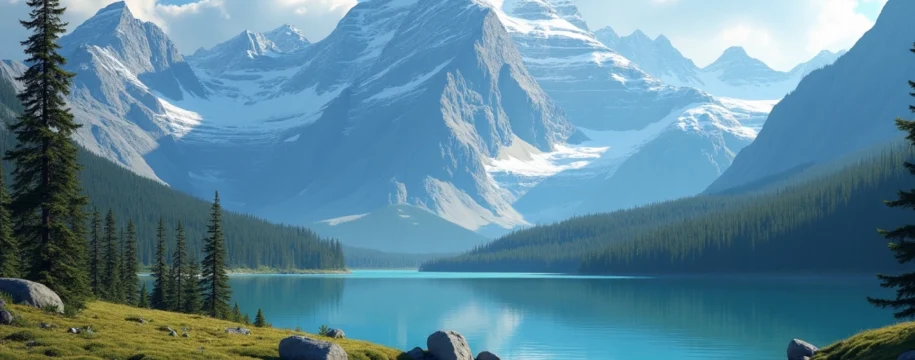
Reflective photography techniques become particularly important when capturing the numerous glacial lakes that dot the Rocky Mountain landscape. Lakes such as Moraine Lake, Emerald Lake, and Maligne Lake offer mirror-like surfaces during calm morning conditions, allowing photographers to create symmetrical compositions that double the visual impact of surrounding peaks. The key to successful reflection photography lies in timing visits during windless periods, typically in the early morning hours before thermal heating creates surface disturbances.
Professional landscape photographers recommend using polarizing filters to reduce glare and enhance color saturation when photographing the turquoise waters characteristic of glacial lakes, while graduated neutral density filters help balance the extreme contrast between bright sky and shadowed foreground elements common in mountain photography.
Macro photography opportunities abound throughout the region’s diverse ecosystems, from dewdrop-covered spiderwebs in montane forests to intricate ice crystal formations on high-altitude rock faces. Alpine wildflower photography presents unique challenges due to harsh environmental conditions and short blooming periods, but rewards patient photographers with images of rare species found nowhere else on Earth. The brief but intense wildflower displays in subalpine meadows typically peak during July and August, requiring precise timing and weather awareness to capture these ephemeral natural spectacles.
Wildlife photography in the Canadian Rockies demands extensive patience and knowledge of animal behavior patterns, as well as telephoto lenses capable of maintaining safe distances from potentially dangerous species. Grizzly bears fishing for salmon in mountain streams provide dramatic action photography opportunities, while mountain goats navigating impossible cliff faces showcase the remarkable adaptations that allow wildlife to thrive in extreme environments. Ethical wildlife photography requires maintaining minimum distances specified by park regulations and never baiting or harassing animals to obtain photographs.
Winter photography in the Canadian Rockies presents both extraordinary opportunities and significant challenges, as extreme cold temperatures can drain camera batteries rapidly and moisture condensation can damage equipment during temperature transitions. However, the winter landscape offers unique compositions unavailable during other seasons, including snow-laden evergreen forests, frozen waterfalls that create stunning ice sculptures, and northern lights displays that paint the night sky in brilliant greens and purples against snow-covered peaks.
Panoramic photography techniques become essential for capturing the vast scale of Rocky Mountain vistas, often requiring multiple overlapping images that are later stitched together in post-processing. The region’s dramatic vertical relief creates opportunities for layered compositions that include foreground, middle ground, and background elements spanning thousands of feet in elevation. Understanding hyperfocal distance calculations becomes crucial when attempting to maintain sharp focus from immediate foreground elements to distant mountain peaks in the same composition.
Storm photography provides some of the most dramatic opportunities in the Canadian Rockies, as weather systems interact with mountainous topography to create spectacular cloud formations, lightning displays, and rapidly changing light conditions. However, lightning safety becomes paramount when photographing storms in exposed alpine environments, requiring photographers to understand weather patterns and maintain safe escape routes to lower elevations when conditions deteriorate.
